| Hiking routes in Cajas | ||||||||||||
| Route or Sendero | Grado | |
|
|
|
|
|
|
|
|
|
|
| AVILAHUAYCO | Principal | 1.6 | 3 | Extremo | *** | 4200 | 3840 | NO | NO | NO | NO | NO |
| GARCIA MORENO | Principal | 3 | 3 | * | * | 3960 | 3720 | SI | SI | SI | NO | SI |
| CUCHEROS BURINES | Secundario | 3 | 2 | ** | * | 4200 | 3880 | NO | SI | SI | NO | NO |
| MAZAN | ||||||||||||
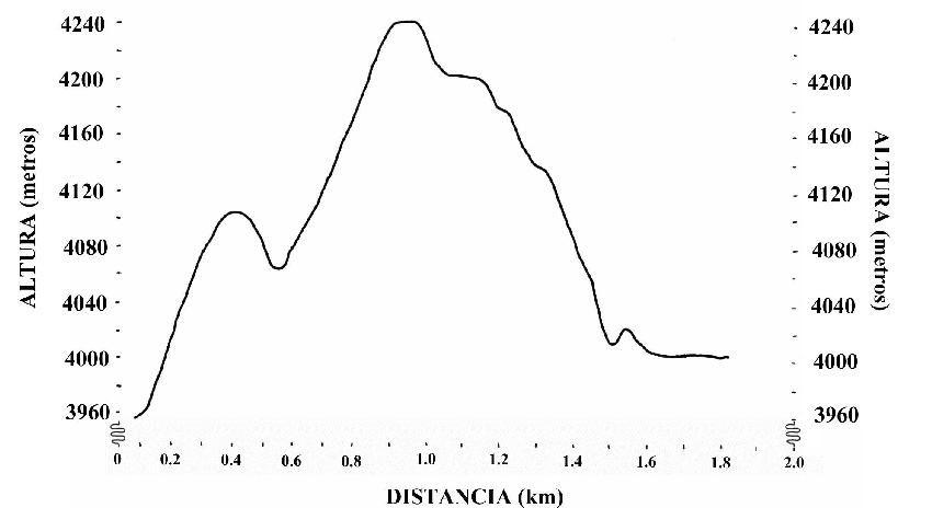
| OSOHUAYCO | Secundario | 10 | 6 | *** | ** | 4120 | 3770 | NO | SI | SI | SI | NO |
| INCA TRAIL | Principal | 20 | 12 | * | *** | 4050 | 3100 | SI | SI | SI | SI | NO |
| LAGUNA TOREADORA | Principal | 2 | * | ** | 3900 | 3800 | SI | SI | SI | NO | SI | |
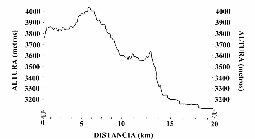
| PARADA PATUL VIRGEN | Principal | 9.2 | 5 | ** | ** | 4250 | 3650 | NO | NO | SI | NO | NO |
| PAREDONES | Principal | 5 | * | * | NO | NO | NO | NO | NO | |||
| SAN LUIS | Principal | 2 | 3 | ** | ** | 4240 | 3960 | SI | NO | SI | NO | SI |
| SHAYANA BURINES | Secundario | 3.6 | 2 | ** | * | 4110 | 3880 | NO | NO | NO | NO | NO |
| TOR - SOLDADOS | Principal | > 30 | 16 | ** | *** | 4150 | 3300 | SI | SI | SI | NO | SI |
| TOR - VIRGEN | Principal | 5.2 | 5 | ** | ** | 3960 | 3720 | SI | SI | SI | NO | SI |
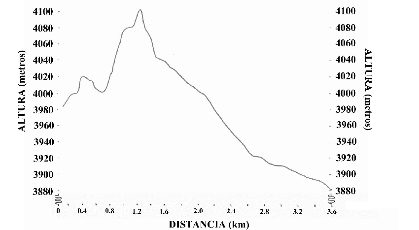
| XXX GUAGRAHUMA | Principal | 3.5 | 3 | * | ** | 4160 | 3860 | NO | SI | SI | SI | NO |
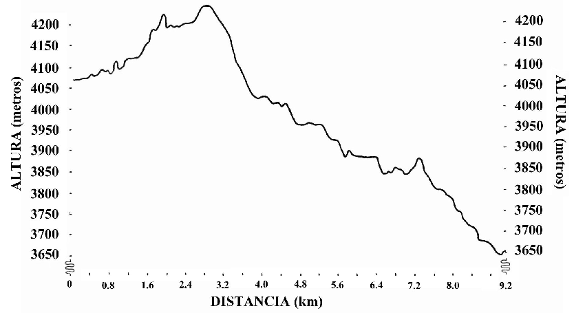
| TOR - LLAVIUCO | Principal | 14 | 12 | ** | *** | 4150 | 3100 | SI | SI | SI | SI | SI |
Click in the left column on the name of the trail for a description in more detail.
Grado means "degree" in Spanish. Principal stands for a hiking track which can be walked from road to road. It is a complete track. Secundario is not a complete track and should always be combined with another hiking track.
The length of the hiking trail measured in kilometers. Climbing and descending is not taken in account.
The duration of the track in hours. This is pure walking time (without rests). Walking time differ strongly per person.
The difficulty of the hiking trail, compared to the other trails. One star is easy, three stars difficult.
Belleza! Or beauty of the track. The most subjective variable in our table. Even an one star beauty trail is very beautiful.
The highest point in the route / track. Use the profiles, if available, in the hiking track description, for a beter insight.
The lowest point in the route / track. Elevation in meters AMSL (above mean sea level)
Information and entrance. Here you can register for your track and possibly get a map.
Campsite. Very basic, a dry place.
Parking.
A cave, can be used as a place to shelter.
El refugio Laguna Toreadora.
Avilahuayco
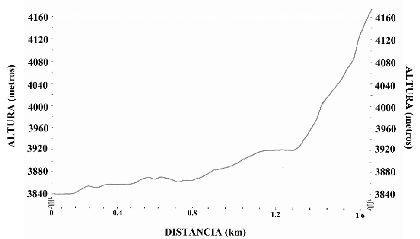
The top of Avilahuayco gives you one of the best panorama's. The description of this track is one-way. You also have to climb down! It is a track with climbing. Only experienced climbers should try this route.
To download the map as a pdf file (0.8 Mb), please click here
 Return to Top
García Moreno
García Moreno, this trail is called after Gabriel García Moreno, a conservative statesman who was twice president of Ecuador (1861-1865 and 1869-1875). The track was used for cars until the new road was built in the ninties of the twentieth century.
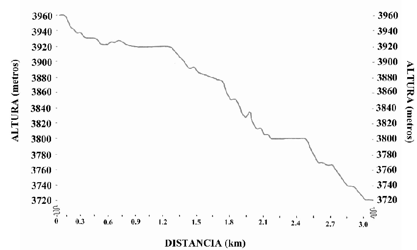
The beginning of the track is a bit hard to find, so if a park ward is around ask him for the beginning of the track. After the walk around laguna Toreadora is this the easiest hike. You almost only walk down hill, no difficult parts (see profile below this text), no difficult stream crossings, and a final destination near the famous trout restaurant / police checkpoint.
To download the map as a pdf file (0.6 Mb), please click here
 Return to Top
Cucheros Burin
This is not a complete track, you have to combine it with another track.
To download the map as a pdf file (0.6 Mb), please click here
 Return to Top
Guagrahama - Mazan
This route may be closed.
 Return to Top
Guagrahuma (Luspa) - Osohuaycu - Toreadora
Description of the route
To download the map as a pdf file (1.5Mb), please click here
Return to TopInca Trail
The Inca trail (also called Ingañán and in Spanish Camino del Inca) is part of the ancient trail from the coast to Tomebamba, nowdays called Cuenca. It is possible to walk this hike from the coast to Cuenca (or reverse). I walked from Paredones to Cuenca (covers the Mountain part of the trail). The track described here is from Guagrahuma to Llaviuco (the Cajas park part of the trail). The trail from Paredones to Guagrahuma is listed under the name Paredones
To download the map as a pdf file (2.2 Mb), please click here
To download the waypoints for a GPS handheld (2 kb, textfile with x and y coordinates, PSAD 56 UTM 17s), please click here
 Return to Top
Laguna Toreadora
Want to wander? This smooth, flat route around the Toreadora lake can be run in 23 minutes, but is mostly walked in 2 hours. Can still be pretty tough when not acclimatised (for example coming from Guayaquil, the coast). End and start is at the ranger station of Laguna Toreadora.
To download the map as a pdf file (0.3 Mb), please click here
Return to TopParada Patul, Laguna Unidas to el Virgen
This is a long day hike which will offer you unique panaroma views (when the weather is good). It will bring you above the 4200 meters and down to 3650 where the "el Virgen" is, the trout restaurant and the police station, a good place to catch the bus back to Cuenca (or up in the direction of the coast). It will not bring you to laguna Toreadora. This hiking trail starts at the stop for the village named Patul. This is mostly known by the bus or taxi drivers as "parada Patul". Especially in the morning you will have a good chance to meet people unpacking cars to load horses, donkeys and themselfs. The first part of your track will be the same as their track. At the highest point, the gate to Patul, your routes will seperate. They will go (north) down to Patul, you stay at the same side and will go down (south-east direction) to "el Virgen". Of course you can pay a visit to the village of Patul. From the gate of Patul you may have a good view. You see the valley split in two valleys, take the right one for Patul. This is outside the park (limit of the park is the saddle).
But first you have to climb up from the bus stop to the highest point, the gate to Patul, which is a climb of more than 200 meters in elevation and about three kilometers in distance. When acclimatised, healthy and trained this will take around two hours. This track is not marked, but very well visible as it is used by the villagers of Patul. After this climb you will mainly go down and pass the "perro" lakes, laguna Unidas and laguna Totoras and Patoquinuas. When you pass laguna Unidas you have the possibility to cut of your hike and go to Laguna Toreadora. There you have the ranger station and the restaurant (sometimes open). This short cut will not save you much time. Only when you have problems going down (for example knee problems) it is a good choice as you end at 3960 meters instead of 3650. The trail down from laguna Unidas is pretty straight foreward. Down, with some little climbing. Not much chance of getting lost, possibility of small detours.
To download the map as a pdf file (0.8 Mb), please click here
 Return to Top
Guagrahuma to Paredones
The paradones trail described here walks from Guagrahuma (western border of Cajas) to Paradones de Molleturo. The archeological site. Contrary to Ingapirca is this site not renovated. It is also much less touristic. Paradones convoked me a more exploring feeling than Ingapirca. This Guagrahuma - Paradones trail is part of the Inca trail and connects with the Cajas Inca trail. The trail itself is also totally different from the cajas tracks. The surroundings are lower situated (elevation around 3000 ? meter) and much more cultivated. You will walk along many small meadows (sometimes a Granja) and meet more local people than in Cajas.
Return to TopCerro San Louis
Cerro de San Louis is a heavy trail, not a long distance but a good climb with spectecular views.
To download the map as a pdf file (0.3 Mb), please click here
 Return to Top
Shayana Burines
This is a secundairy route and has to be combined with another track. Also named Inganan, as you walk along laguna Inganan
To download the map as a pdf file (0.6 Mb), please click here
 Return to Top
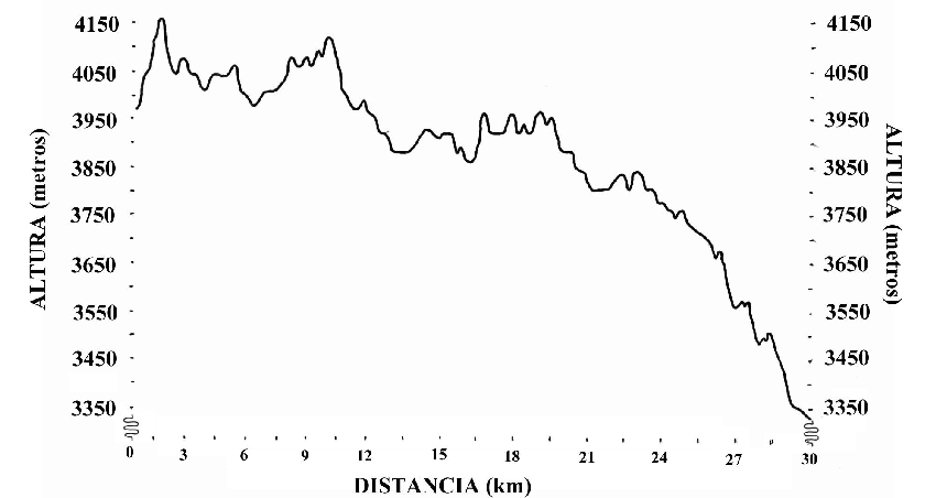
Laguna Toreadora to Soldados
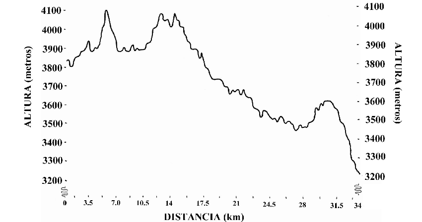
This is the longest track in Cajas and will take you from north to south (unlike most east-west orientated trails). Starting at laguna Toreadora, crosses the Inca trail and along laguna Osohuaycu, laguna Alumbre, laguna Pena Amarilla, laguna Inca Carretera, laguna Ventanas and laguna Estrellas Cocha. The hike described here has been walked with horses and therefor mostly not walked in the valleys but on the hill sides. The hoofs of the horses sag less in the firmer soil. This is the most most remote track in Cajas. This does not mean you will not encounter other human being as at the more southern part of this track is the backyard of rio blanco and other settlements at the western side of the park. German Guittieres (park guide) and I met during our horse ride several people on horses armed with guns and freshly shot game (of course claimed to be bought at the local market). Do not get confused by my previous anecdote, walking this trail will be lonely experience. Good places to camp are are near laguna Osohuayco, or a bit more south Alumbre (where you cross the Luspa - Osohuayco - laguna Toreadora trail). Another good place may be at the shores of laguna Ventanas)
To download the map as a pdf file (3.5 Mb), please click here
 Return to Top
Laguna Toreadora - Laguna Unidas - el Virgen
Nice civilised hike, with a good starting point: refugio de laguna Toreadora and good end point: el Virgen, with the police check point, good to have a nice trout in the restaurant and catch a bus back to Cuenca. You pass and cross a dwarf tree forest (Polylepis weberbaueri). It is since 2006 on the IUCN list of threatned species. Walking through such a forest is like a fairytail. The bark looks like it is made of many paper sheets. The branches are tortuous, which makes the forests not very easy to pass / cross.
To download the map as a pdf file (0.8 Mb), please click here
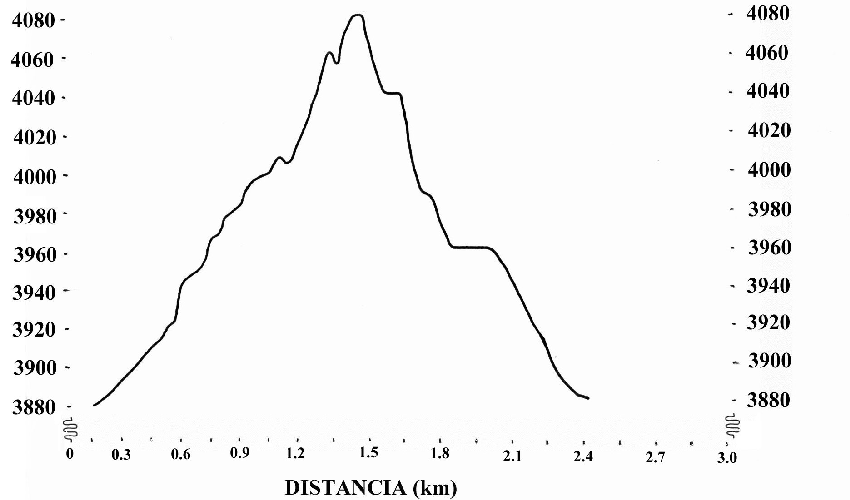
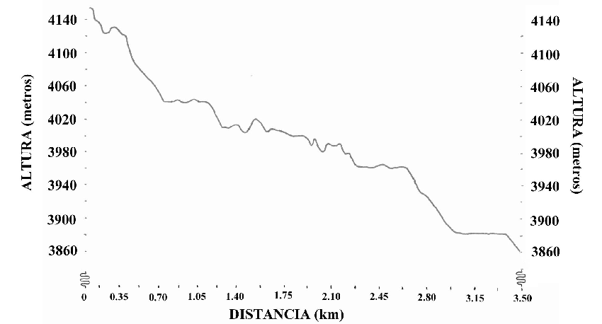
Return to TopTres Cruces (XXX) - Laguna Luspa - Guagrahuma
The profile shown below this text shows the track from Tres Cruces to Laguna Luspa. The last part of the track from Luspa to the road, Guagrahuma, is not shown.
To download the map as a pdf file (0.5 Mb), please click here
 Return to Top
Laguna Toreadora to Laguna LLaviuco via Burin
A long day hike consisting of a good part of the Inca trail. Starting at the ranger station at laguna Toreadora and ending at a park entrance LLaviuco.
To download the map as a pdf file (2.5 Mb), please click here
Return to Top